A look at our community's past

Author: Leslie (Page 1 of 7)

An Overview of Ames Lake Region Geology

The Glaciers Come and the Glaciers Go…

Written by Bert Pschunder 

Introduction                                                                    

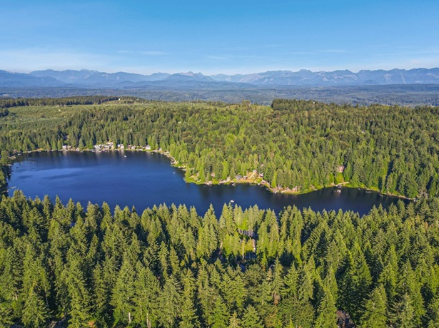
The action of glaciers in recent geologic time has had a significant influence on the shape of the land at Ames Lake and the surrounding region. Lake topography, along with nearby deeply incised drainage channels and steepened hillsides, are the result of the repeated movement of glaciers and subsequent large quantities of glacial meltwater flowing across the uplands we know today as Tolt Hill and Union Hill. The lake itself owes its very existence to dynamic processes that closed out the most recent glacial episode in the Puget Sound region.

Also, our Ames Lake region is within a very seismically active zone as evidenced by faults and earthquakes, some of which have been recently mapped around Ames Lake and in the nearby Snoqualmie Valley.

The recent mapping and an accompanying report are presented for the Carnation, Washington quadrangle by Dragovich et al., (2010). An excerpt from their map showing the lake area is included as Figure 1.
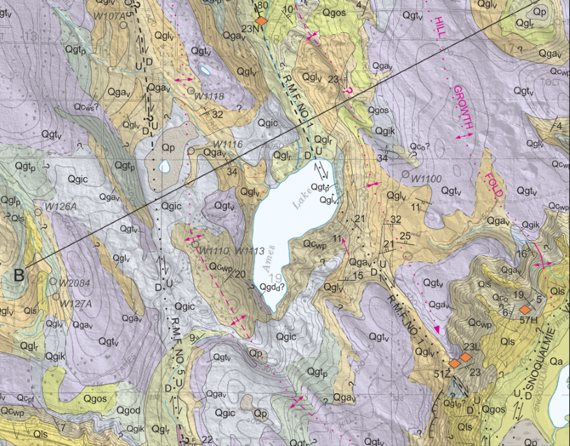
Figure 1: Excerpt from Carnation quadrangle geologic map (from Dragovich et al. (2010)

The Glaciers Leave Their Mark

Glaciers are large masses of ice that can be thousands of feet thick. They can move as the ice thickness increases, albeit very slowly. There is evidence that the Puget Sound region has experienced several large-scale glacial advances originating from up north in British Columbia, Canada and reaching as far south as the Olympia, Washington area.

As the glaciers moved southward to and across our Ames Lake region, they picked up rocks, sand and silt. Some of this sediment was deposited under the glacier and also along the sides of the glacier as it moved. These deposits, known as glacial till, formed ridges and hills such as Union Hill, Tolt Hill and the Sammamish Plateau. It is interesting to note that quite a bit of the gravel, cobbles and boulders we encounter in our area can be traced back to the mountains of British Columbia.

The glaciers also scoured out river valleys (for example, the Snoqualmie Valley) previously formed in weaker bedrock. The weaker bedrock zones were likely the result of faulting (bedrock movement and fracturing).

Figure 2 is a Light Detection and Ranging (LIDAR) image of the Union Hill/Tolt Hill region showing Ames Lake and the surrounding terrain. (LIDAR is an aerial technique that allows us to “remove” vegetation and look directly at land surface features.)  In Figure 2, we can see the northwest-to-southeast “grain”, or trend, of the land surface caused by the flow of the glaciers.
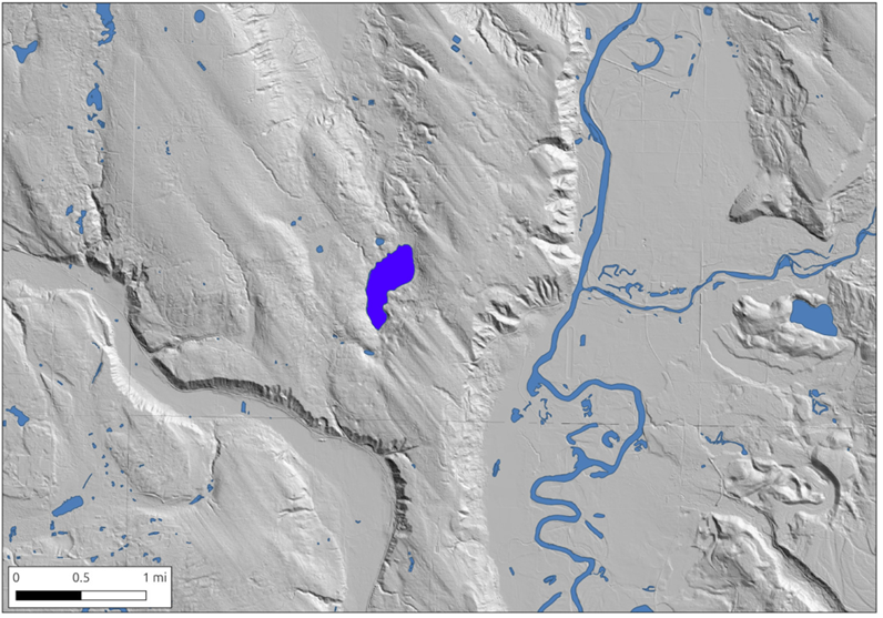
Figure 2: LIDAR terrain (from Washington Department of Natural Resource LIDAR portal, 2021)

The till left behind by the glaciers forms much of the higher ground and plateaus surrounding Ames Lake. Lake area residents can attest to the difficulty of digging into the very dense till and encountering the abundant rocks included in the till. This is because the weight of thousands of feet of ice has highly compacted the deposits so that a pick or a jackhammer is needed.

Now about Ames Lake:  As the climate warmed at the end of the last glacial episode, the ice melted before new ice could take its place and then eventually disappeared. It’s very likely a big ice block became stranded where the lake is now located. As the ice block melted, the rocks, sand and silt that were contained within it got carried by streams of meltwater. The meltwater flowed off the sides of the ice, as if the ice block were a large mound. The rocks, sand and silt were eventually deposited around the edges of the ice block. Geologists call these deposits ‘Ice-contact stratified drift”. These deposits, plus the glacial till described above, form the band or rim of higher ground around the lake. (Figure 1 shows these deposits as varying colored map units.)

Once the ice was gone, a depression was left in its place. Geologists call a depression formed in this way a “kettle.” If water fills the depression, it’s a “kettle lake.”

Fault Lines and Earthquake History

Looking more closely at Figure 1, one can see a mapped fault passing through the north end of Ames Lake. In the bigger geologic picture, there are several fault zones in the Snoqualmie Valley area; these are described in the Dragovich et al. report. Most of the related faults are oriented in a northwest-to-southeast direction. The faults are the result of a long history of crustal movements in the Pacific Northwest.

Of particular interest for Ames Lake is the mapped Rattlesnake Mountain Fault No. 1 (“R.M.F. NO. 1” on the map). The Dragovich et al. report indicates that this fault is the main fault in the Rattlesnake Mountain Fault Zone. The Rattlesnake Mountain Fault Zone is a substantial fault system that extends from Whidbey Island southeast to the City of Seattle Watershed near North Bend. The faults in this zone are thought to be strike-slip or oblique-slip offset faults, meaning that the bedrock on one side of the fault moves horizontally (and somewhat vertically) relative to the other side.

Evidence for the faults includes liquefaction features and shallow seismic (earthquake) activity. Interestingly, in 2010, the same year the Carnation geologic map was published, a small (magnitude 3.4) earthquake was detected with its epicenter near the Vincent Schoolhouse on West Snoqualmie Valley Road. This earthquake had a focal depth of 3.9 miles.

Conclusion

The geologic processes that have shaped the Ames Lake region are complex but becoming better understood with time.  There’s much more to learn, but at least we have an appreciation for how our lake and the surrounding higher ground were probably formed.

For additional information about earthquakes in the Pacific Northwest, see the following website: https://pnsn.org/

References

Dragovich, J. D.; Littke, H. A.; Anderson, M. L.; Wessel, G. R.; Koger, C. J.; Saltonstall, J. H.; MacDonald, J. H., Jr.; Mahan, S. A.; DuFrane, S. A., 2010, Geologic Map of the Carnation 7.5-minute quadrangle, King County, Washington: Washington Division of Geology and Earth Resources Open File Report 2010-1, 1 sheet, scale 1:24,000, with 21 p. text.

Washington Department of Natural Resources LIDAR portal, 2021, https://lidarportal.dnr.wa.gov/   Data produced for USGS.
When Everyone in Ames Lake Knew Everyone

The first time Charlotte Fykerud saw Ames Lake was in 1962. She was invited by a homeowner’s friend to go fishing on the lake, which was stocked with trout. She remembers there were very few houses then and the vegetation continued all the way down to the water.

“It looked so dense and primeval,” she said.

In 1965, Charlotte and her husband Jack bought a little cabin on the west side of the lake. After being there for just 5 days, their eldest son Eric was born, followed by their son Kurt in 1968. There were not many families here at the time and only two had children the same age.

Ames Lake Community Club meetings

One of the first things Charlotte and Jack did when they moved here was to attend an Ames Lake Community Club meeting. The Community Club was initially formed to deal with the issue of public fishing on the lake. It was discussed for months.

“In 1965, everyone in the community knew everyone,” Charlotte said. “There was no formal process for meeting, we just met.”

“Sometimes the women around the lake had coffee together and gossiped. Several of the conversations we had were about the awful phone service around the lake. You could call Carnation, Fall City, Snoqualmie, and North Bend, but Redmond was long distance. If you wanted to call there, you had to go down to the store, located where the gas station at 244th is now, and use a public phone mounted on the outside wall. Otherwise, the rates added up quickly.”

Charlotte and Jack bought the lot she lives on now in 1969, also on the west side of the lake. Construction began in March 1970, and they moved there in July of 1973.

“I love it here,” Charlotte said. “When I look around the lake now, even with all the houses and lights, it still doesn’t look that populated. I’m never going to leave Ames Lake.”

Growing Up in Ames Lake – the 1970s

Kim Ross moved to Ames Lake with her family in 1970, when she was 7 years old. They were living in Santa Barbara when her parents, both teachers, decided to move back to the Seattle area. Her mother had grown up here, as had her grandmother.

Kim’s parents looked for property all around King County. One day they found a flyer for a house on Ames Lake. Owned by the Cartozians, a prominent Seattle family, the house had been on the market for three years. They were asking $67,000.

The night before they went to see the house, Kim saw it all in a dream.

“I saw the house, a woodshed, a jar on a shelf inside the woodshed, and a German Shepherd at the door.”

The next morning when they got there, the jar was right where she saw it in her dream. The dog was there too. As far as Kim was concerned, the house was meant to be.

The Cartozians

The Cartozians originally built a small log cabin on their property, which they purchased in 1946. In 1963, they hired an architect to design a new, bigger house. The cabin was lifted up, a foundation was laid, and the cabin was put back down on the same spot. You can still see the original logs in the walls of the 5,400 square foot house, where Kim still lives.

The community was a lot smaller in the 1970s. The kids all knew each other from riding the bus to Fall City Elementary School or to the junior high and high school in Snoqualmie. In the summer, they played together in the lake, swimming and boating to each other’s houses.

The Ames Lake Community Club meetings were fun events. Held at the Grange, as they are now, there was always a potluck, the kids played, and everyone gossiped. The whole community fit into that one room.

The train depot

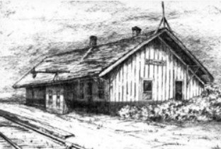
In 1971, Kim’s father, Bowman Ross, heard the Redmond train depot was for sale. It was just $10.00. He bought it, and with the help of his three young daughters, he slowly dismantled the building over the next three months.

He then used the lumber to build a stable on their property, which became home to three horses – Laddy, their Welsh pony from Carnation Farms, another Welsh pony owned by their neighbor, Sharon Miller, and an Arabian Quarter Horse that belonged to a friend in Seattle. Kim and her sisters, Leigh and Mary, rode the horses up on the logging trails, which are now 289th and 290th streets.

“The surrounding area was all wilderness then,” Kim reminisced. “An abandoned apple orchard was tucked into the forest, and there were mud puddles brimming with polliwogs. Ames Lake was a happy place to grow up.”

The Physical Geography of Ames Lake – Interesting Facts

  • Ames Lake is located in Eastern King County, Washington, at Latitude 47o 38’ 40’’ North and Longitude 121o 57’ 20’’ West. It is within Section 19 of Township 25 North, Range 7 East.
  • The lake surface is at Elevation 240 feet above mean sea level (NGVD 1929 datum).
  • The area of the lake is 80 acres. It is roughly kidney-shaped and is about 0.6 miles long (north-south) by 0.25 miles wide in the north half, narrowing to about 0.1 miles wide in the south half.
  • Volume of the lake is about 1400 acre-feet.
  • The lake is within the Snoqualmie River Basin and has a drainage area of 1.84 square miles.
  • The lake has an inlet stream along the northwest side and an outlet stream at the north end. The outlet stream follows Ames Lake-Carnation Road down to the Snoqualmie Valley, where it eventually enters the river about 3-1/2 miles north of the lake.
  • The mean depth of the lake is 18 feet, and the maximum depth is 28 feet, which occurs near the south end of the lake.
  • Shoreline length of the lake is 1.5 miles.

References

Bortleson, G.C., Dion, N.P., McConnell, J.B., and Nelson, L.M. (1976). Reconnaissance Data on Lakes in Washington, Volume 2, Washington State Department of Ecology and U.S. Department of the Interior Water Supply Bulletin 43, Volume 2.

Topographic Map of the Carnation, Washington 7.5 Minute Quadrangle (photo revised in 1973), U.S. Geological Survey.


A Brief History of Tanner Electric Cooperative

Tanner Electric Cooperative was founded in 1936 as the “Mutual Power and Light Association of Tanner.” They provided electric service for people in the southeast area of North Bend who could not afford to pay the costs required by the power company.

The Cooperative’s original group approached the Rural Electrification Administration, and with the assistance of J.D. Ross (then Superintendent of Seattle City Light), they were able to obtain the first R.E.A. loan in the State of Washington. This $13,000.00 loan made it possible to construct 13 miles of line to 32 members. By the end of 1937, the contracts were set, and the Cooperative had their first 32 members. They purchased 6,000 kWh from Seattle City Light’s Cedar Falls plant, and the revenue that first year was $286.67.

From 1937 to 1947, all the Cooperative’s power was purchased from Seattle City Light at Cedar Falls. In 1947, they signed the first contract with the Bonneville Power Administration and began to purchase Bonneville power from Seattle City Light. The arrangement with Seattle continued until November 1966, when a new Bonneville contract shifted the point of delivery for power in the North Bend area to the North Bend substation of Puget Sound Power and Light Company.

Purchasing power from Puget Sound Energy

In 1954, the residences of Ames Lake tried to obtain power from Puget Sound Energy, but they were not successful. Later that year, Tanner Electric signed a contract with Puget Sound Energy to purchase power that would serve Ames Lake. That year, Tanner Electric constructed the necessary lines and began service to approximately 50 members.

By 2016, North Bend served 2,073 meters and Ames Lake served 1,450 meters.

In 1960, the Rural Electric Association (REA) asked the Cooperative to serve Anderson Island. They installed a two-mile submersible cable, and in late 1961, the first 44 members were connected.

By 2016, Anderson Island served 1,176 meters.

Tanner Electric membership

We have experienced quite a few changes since then. We now have 4,699 meters, both residential and commercial, within our membership.

Tanner Electric Cooperative is a non-profit utility company that puts people and community, not capital, at the center of their business. They contribute to the community through various organizations, such as the Snoqualmie Valley Rotary, Little League sponsorship, and the Snoqualmie Valley Chamber of Commerce. They also provide scholarships to our local high school students whose parents are members of the Cooperative.


Farming and Rural Life in the Snoqualmie Valley – the Ames Lake Connection

Nestled between Redmond and Carnation, the Ames Lake area has always existed on the edge of the rich agricultural lands of the Snoqualmie Valley. While Ames Lake itself became better known in the twentieth century as a rural residential and recreation community, its history is deeply tied to the farming traditions that shaped the entire valley for more than 150 years.

Long before modern roads and neighborhoods appeared, the Snoqualmie Valley was a landscape of forests, rivers, prairies, and fertile floodplains. Native Snoqualmie people used the valley seasonally for fishing, gathering berries, and harvesting roots. Later, Euro-American settlers recognized the valley’s extraordinary agricultural potential and began establishing farms in the mid-1800s.

Early Settlement and Farming

Permanent settlement in the Snoqualmie Valley began in the 1850s and 1860s. Early pioneers such as Jeremiah Borst and other homesteaders claimed land along the river and open prairie areas. These first farms were small and largely self-sufficient, producing vegetables, grain, livestock, and dairy products for local use.

Much of the lower valley, however, was still heavily forested. Logging often came first. Settlers worked in logging camps while gradually clearing land for agriculture. Trees were felled, burned, and removed over years of hard labor before the land could support crops or pasture. Farmers frequently supplemented their income by producing cedar shakes, shingles, and timber products.

The Ames Lake area followed this same pattern. The surrounding hills were heavily logged in the early twentieth century, especially during the 1920s. Old railroad grades and logging routes can still be traced through the woods around Ames Lake today.

« Older posts