The Glaciers Come and the Glaciers Go…
Written by Bert Pschunder
Introduction
The action of glaciers in recent geologic time has had a significant influence on the shape of the land at Ames Lake and the surrounding region. Lake topography, along with nearby deeply incised drainage channels and steepened hillsides, are the result of the repeated movement of glaciers and subsequent large quantities of glacial meltwater flowing across the uplands we know today as Tolt Hill and Union Hill. The lake itself owes its very existence to dynamic processes that closed out the most recent glacial episode in the Puget Sound region.
Also, our Ames Lake region is within a very seismically active zone as evidenced by faults and earthquakes, some of which have been recently mapped around Ames Lake and in the nearby Snoqualmie Valley.
The recent mapping and an accompanying report are presented for the Carnation, Washington quadrangle by Dragovich et al., (2010). An excerpt from their map showing the lake area is included as Figure 1.

The Glaciers Leave Their Mark
Glaciers are large masses of ice that can be thousands of feet thick. They can move as the ice thickness increases, albeit very slowly. There is evidence that the Puget Sound region has experienced several large-scale glacial advances originating from up north in British Columbia, Canada and reaching as far south as the Olympia, Washington area.
As the glaciers moved southward to and across our Ames Lake region, they picked up rocks, sand and silt. Some of this sediment was deposited under the glacier and also along the sides of the glacier as it moved. These deposits, known as glacial till, formed ridges and hills such as Union Hill, Tolt Hill and the Sammamish Plateau. It is interesting to note that quite a bit of the gravel, cobbles and boulders we encounter in our area can be traced back to the mountains of British Columbia.
The glaciers also scoured out river valleys (for example, the Snoqualmie Valley) previously formed in weaker bedrock. The weaker bedrock zones were likely the result of faulting (bedrock movement and fracturing).
Figure 2 is a Light Detection and Ranging (LIDAR) image of the Union Hill/Tolt Hill region showing Ames Lake and the surrounding terrain. (LIDAR is an aerial technique that allows us to “remove” vegetation and look directly at land surface features.) In Figure 2, we can see the northwest-to-southeast “grain”, or trend, of the land surface caused by the flow of the glaciers.
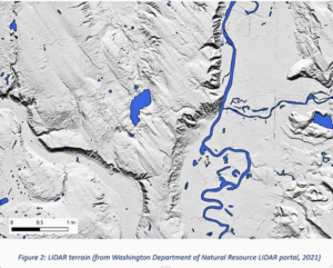
The till left behind by the glaciers forms much of the higher ground and plateaus surrounding Ames Lake. Lake area residents can attest to the difficulty of digging into the very dense till and encountering the abundant rocks included in the till. This is because the weight of thousands of feet of ice has highly compacted the deposits so that a pick or a jackhammer is needed.
Now About Ames Lake
As the climate warmed at the end of the last glacial episode, the ice melted before new ice could take its place and then eventually disappeared. It’s very likely a big ice block became stranded where the lake is now located. As the ice block melted, the rocks, sand and silt that were contained within it got carried by streams of meltwater. The meltwater flowed off the sides of the ice, as if the ice block were a large mound. The rocks, sand and silt were eventually deposited around the edges of the ice block. Geologists call these deposits ‘Ice-contact stratified drift”. These deposits, plus the glacial till described above, form the band or rim of higher ground around the lake. (Figure 1 shows these deposits as varying colored map units.)
Once the ice was gone, a depression was left in its place. Geologists call a depression formed in this way a “kettle.” If water fills the depression, it’s a “kettle lake.”
Fault Lines and Earthquake History
Looking more closely at Figure 1, one can see a mapped fault passing through the north end of Ames Lake. In the bigger geologic picture, there are several fault zones in the Snoqualmie Valley area; these are described in the Dragovich et al. report. Most of the related faults are oriented in a northwest-to-southeast direction. The faults are the result of a long history of crustal movements in the Pacific Northwest.
Of particular interest for Ames Lake is the mapped Rattlesnake Mountain Fault No. 1 (“R.M.F. NO. 1” on the map). The Dragovich et al. report indicates that this fault is the main fault in the Rattlesnake Mountain Fault Zone. The Rattlesnake Mountain Fault Zone is a substantial fault system that extends from Whidbey Island southeast to the City of Seattle Watershed near North Bend. The faults in this zone are thought to be strike-slip or oblique-slip offset faults, meaning that the bedrock on one side of the fault moves horizontally (and somewhat vertically) relative to the other side.
Evidence for the faults includes liquefaction features and shallow seismic (earthquake) activity. Interestingly, in 2010, the same year the Carnation geologic map was published, a small (magnitude 3.4) earthquake was detected with its epicenter near the Vincent Schoolhouse on West Snoqualmie Valley Road. This earthquake had a focal depth of 3.9 miles.
Conclusion
The geologic processes that have shaped the Ames Lake region are complex but becoming better understood with time. There’s much more to learn, but at least we have an appreciation for how our lake and the surrounding higher ground were probably formed.
For additional information about earthquakes in the Pacific Northwest, see the following website: https://pnsn.org/
References
Dragovich, J. D.; Littke, H. A.; Anderson, M. L.; Wessel, G. R.; Koger, C. J.; Saltonstall, J. H.; MacDonald, J. H., Jr.; Mahan, S. A.; DuFrane, S. A., 2010, Geologic Map of the Carnation 7.5-minute quadrangle, King County, Washington: Washington Division of Geology and Earth Resources Open File Report 2010-1, 1 sheet, scale 1:24,000, with 21 p. text.
Washington Department of Natural Resources LIDAR portal, 2021, https://lidarportal.dnr.wa.gov/ Data produced for USGS.
Leave a Reply
You must be logged in to post a comment.