The new ALWA Board
The Board consisted of seven elected members (and still does), each serving three-year terms. The first Board President was Gene Peters. The first Secretary, Renny Lillejord, was the Association’s Manager for many years. Early Association board meetings were held around an old card table in the cramped Vista well building.
Annual meetings started taking place at the beginning of the Association. These meetings typically included reading of minutes, financial reports, manager’s reports, and election of Board Trustees (later, Directors). This provided an opportunity for Association members to learn about water system improvements and business operations.
Over time, the annual meetings started to include information about regional water supply issues, water use efficiency, water quality, and origin of the members’ groundwater. Membership in the Association changed with new home/property owners. There have been a wide variety of characters, from a rocket scientist to TV celebrities and professional athletes.
In the early years of the Association, the annual meetings were held at the old Vincent Schoolhouse on West Snoqualmie Valley Road and at various locations in Fall City, Carnation, and Redmond. The Association’s office was initially located in Redmond. It was then moved to a small metal garage/house in Fall City, owned by the Fall City Water District, where it stayed for many years.
Annual meetings are now held at the Association’s office building near Ames Lake, at 27905 NE 33rd Street .
Improvements to the water system
Since its inception, many improvements have been made to the water system . In 1988, the new Marshall Well, located east of the lake along 290th Avenue NE, and a 205,000-gallon storage tank, have been added to the system.
By 1989, 20 years after the Association was formed, there were nearly 600 members. Management and operation of the system continued under Renny and his company, L & R Systems, later known as Satellite Management Services. By 1991, another new tank (158,000-gallon capacity) and the American Hills Well came on line. The American Hills well was the first one located in the southern portion of the Association’s service area and was a significant improvement to the water system.
By 1994, the 25th year of the Association’s existence, membership had grown to 840, and the system’s coverage area included nearly 10 square miles. Soon after, the Daniels Ranch and Quail Creek plats were added to the system. The Association also assumed ownership of a well in Daniels Ranch drilled by the developer. For 25 year, the Association has been adding water mains and supply services to new members.
It’s a good time to remind ourselves that a water utility is not just about supplying water for coffee and a shower in the morning. One of the founding principles of early water systems was to supply fire suppression water for fighting fires, in addition to potable water. If the Association had built a water system just to supply potable needs to its members, it would have been a much smaller (in pipe diameter and water storage) and less costly system to meet fire flow requirements than larger diameter pipes, pumps, hydrants, and significant water storage used to keep fighting fires. Thankfully, the Association’s founding members thought some firefighting capacity would be a good idea for those living in remote forested areas. In the early days of the Association, water storage tank management to maintain adequate levels for firefighting and domestic needs sometimes took precedence over outside watering during hot summer days.
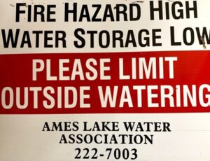
Neighborhood sign in the 1970s -1980s
Regulations and water rights
Over the years, the Association has had to comply with many new regulations and water supply related issues. These included the development of Comprehensive Water System Plans, Water Conservation Programs, Wellhead Protection Plans, and Emergency Management Plans. A Board member and later a consultant to the Association, Bob Pancoast, was instrumental in addressing these regulations and communicating them to the Association members. Bob also initiated Geographic Information System (GIS) mapping of the Association’s facilities. He applied for grant funds from the Department of Ecology that financed the initial telemetry systems within the ALWA system.